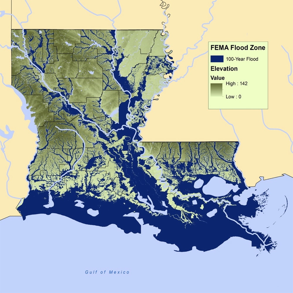
Louisiana faces some of the nation’s toughest flood challenges. Much of southern Louisiana — from the Mississippi River to the Gulf Coast — lies at or below sea level. Heavy rain storms, hurricanes, and subsidence mean floods can happen quickly and unexpectedly. The map below highlights Louisiana’s “100-year” floodplain (dark blue) – areas FEMA defines as high-risk because they have a 1% or greater chance of flooding each year. Living in these zones means at least a 1-in-4 chance of flooding during a typical 30-year mortgage. Even outside official floodplains, water can still rise (about one-third of flood insurance claims come from outside FEMA’s 100-year zones). Understanding your flood risk is the first step to keeping your property and family safe.
What Are High-Risk Flood Zones?
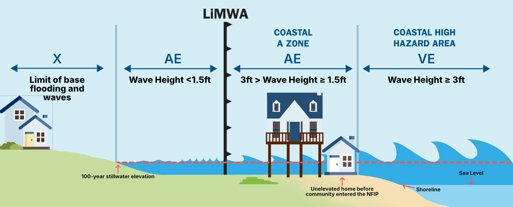
Federal flood maps (FEMA’s Flood Insurance Rate Maps) divide areas into flood-risk categories. A high-risk flood zone is any area with at least a 1% annual chance of flooding. This includes FEMA’s special flood hazard areas (commonly “Zone A” or “Zone V”). In practical terms, if you live in a high-risk zone, you have about a 50-50 chance of flooding over 70 years. You can view the latest flood maps at FEMA’s Map Service Center or at Louisiana’s FloodMaps portal. Always remember: no area is completely risk-free — even “X” zones with lower risk can flood under extreme conditions.
Key points about flood zones in Louisiana:
- Coastal vs. Inland: Coastal areas (Zones V/AE) face storm surge and tides, while inland floodplains (Zone A/AE) flood from heavy rain and river overflow. Southeastern Louisiana has both kinds of risk (e.g., New Orleans has storm surge risk, while Baton Rouge faces river and rain floods).
- FEMA and Insurance: Mortgage lenders usually require flood insurance for homes in FEMA high-risk zones. Louisiana law enforces these requirements strictly because of historic flood losses.
- Changing Designations: Flood maps can change. New data may move areas into higher-risk categories over time. Always re-check your flood zone whenever FEMA releases new maps.
Louisiana’s Geography and Growing Flood Risk
Louisiana’s unique geography — low elevation, vast wetlands, and a powerful river delta — makes flood risk especially severe. Southeastern Louisiana averages only 3 feet above sea level. Meanwhile, land is disappearing: scientists estimate nearly 2,000 square miles of Louisiana coastal land have been lost from 1932 to 2016. This is approximately the size of Delaware.
Much of that loss is due to subsidence (the land sinking as sediments compact) combined with limited new sediment from the river due to levees blocking sediment and sea level rise. In some parts of Louisiana, the relative sea level is rising about four times faster than the global average.
Key factors fueling Louisiana’s flood risk include:
- Land loss & subsidence: Southern Louisiana is experiencing some of the fastest coastal land loss on Earth. As marshes and barrier islands vanish, there is less buffer to absorb storm surge from powerful storms.
- Intensifying storms: The Gulf Coast has seen more frequent and stronger hurricanes and tropical storms. Even tropical storms and summer squalls can unleash torrential rain. These storms dump enormous amounts of water on Louisiana’s flat landscape.
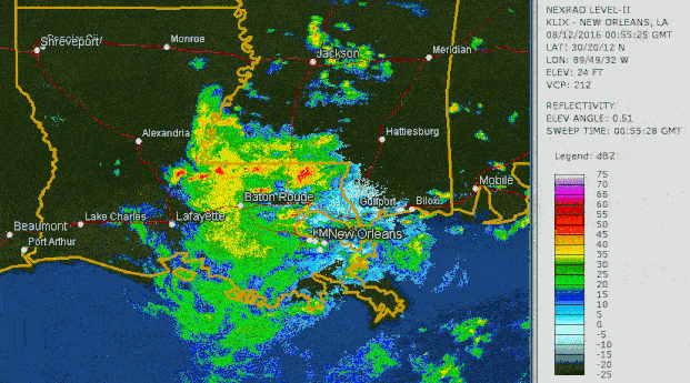
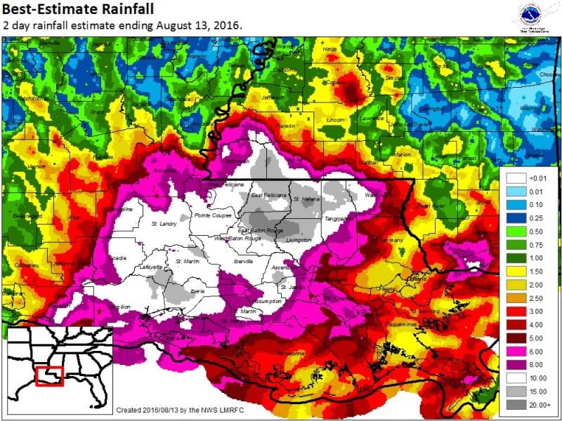
- Rainfall extremes: Louisiana’s rainy climate is becoming more extreme. For example, in August 2016 a stalled storm system dumped 20–30 inches of rain across parts of southeast Louisiana. Heavy downpours like that can overwhelm drainage systems and rivers.
Together, these trends mean high-risk zones are effectively expanding. Areas that rarely flooded in the past may now see floodwaters more often. Even communities farther from the coast (like Baton Rouge) must be vigilant when tropical moisture streams inland or the Mississippi swells.
Historic Flooding in South Louisiana
Louisiana’s flood history is a testament to its vulnerability. Every generation recalls major floods. Recent examples highlight the danger:
- Baton Rouge August 2016 Flood: A slow-moving storm unleashed 20–30 inches of rain across East Baton Rouge and surrounding parishes. This triggered catastrophic flooding — estimates are 50,000–75,000 homes and businesses were inundated in East Baton Rouge and nearby areas. Interstates were shut down, and 13 lives were tragically lost in this single event.
- Hurricane Ida (2021): Ida brought a devastating storm surge and heavy rains. Parts of southeast Louisiana saw over 7 feet of surge floodwater; levees in Plaquemines and St. Bernard parishes were overtopped.
- Historic Storms: Katrina (2005) flooded 80% of New Orleans due to levee breaches. Betsy (1965) broke multiple levees in New Orleans. The Great Mississippi Flood of 1927 inundated much of east-central Louisiana. Each event reshaped how the region manages water, but flood risk remains ever-present.
These events underscore that both coastal and inland floods can paralyze communities. In low-lying areas, even lesser storms can have big impacts. Past disasters have also shown that damage often extends beyond officially designated flood zones. For instance, Hurricane Harvey (2017) in Houston flooded many homes outside FEMA’s 100-year floodplain. This highlights an important lesson: you don’t have to be in a designated floodplain to flood.
Protecting Your Home and Community
With flood risk growing, Louisiana residents should take proactive steps:
- Know Your Zone: Check FEMA’s Map Service Center or Louisiana’s FloodMaps portal to see if your address is in a high-risk area. You can also contact local floodplain officials (e.g., parish planning office) to confirm.
- Get Flood Insurance: If you live in a FEMA Zone A/V (high-risk), flood insurance is required by most mortgage lenders. Louisiana homeowners should not rely on standard homeowner’s policies which typically exclude flood damage. Instead, buy a separate flood policy.
- Elevate and Mitigate: If you’re in a flood-prone spot, consider property improvements: elevate your home or critical equipment (furnace, electric panel) above the base flood elevation, add flood vents under the house, or install a sump pump. Studies show even a few feet of “freeboard” (extra height above flood level) dramatically cuts flood damage. Note that Louisiana’s statewide building code still has no mandatory freeboard requirement , so many older homes sit at the same elevation they were built decades ago. Upgrading now can protect your investment and lower future insurance costs.
- Prepare and Plan: Keep an emergency kit (flashlights, batteries, food) and a family evacuation plan ready. Know alternate routes out of your neighborhood (higher roads or bridges). During heavy rains or tropical threats, monitor local radio/NOAA alerts. Sign up for flood warnings from the National Weather Service or parish alert systems. Above all, never drive through flooded roads — it’s one of the leading causes of flood fatalities.
- Stay Informed: Flood risk can change over time. After big storms, watch for new flood maps or local guidance. Louisiana’s floodplain administrators often update maps; communities may also implement new floodwater control projects (like pumps or levees).
Louisiana communities have learned the hard way: flood safety saves lives and property. Universities like LSU have even developed tools (Flood Safe Home) to help homeowners see how elevation affects risk. But ultimately the best protection is insurance plus preparedness. Paying premiums is far cheaper than rebuilding after a disaster.
Get Help from Lewis Mohr Insurance Agency
If you live in Baton Rouge or anywhere in Louisiana, Lewis Mohr Insurance Agency is here for you. We understand local flood dynamics — from Gulf storms to river overflows – and we offer the insurance solutions you need. In addition to flood insurance, we provide homeowners, commercial, and property policies tailored to our region’s risks. Our team can review your property’s flood zone, explain coverage options (NFIP and private), and help you get quotes that fit your budget. Don’t wait for the next storm: call us today or send us a message to learn how to protect your home or business. Lewis Mohr Insurance is proud to help Louisiana families navigate their flood risk.
Sources: Official data and reports from FEMA, NOAA, LSU, and EPA were used to inform this article.